The Blue Mountains have some of the best hiking trails in NSW. The scenery is stunning, and the trails are very diverse. You can walk to amazing viewpoints, swim under waterfalls, explore rainforest paths, trek through slot canyons, and even see glow worms. The mountains truly offer everything!
Note: Make sure your trail is open at Parks NSW website
Here is the Complete Guide to the Best Walks in the Blue Mountains
The Grand Canyon Track – Blackheath

Distance: Approximately 6.3 km (round trip)
Duration: 2.5 to 3 hours
Difficulty: Moderate
Trail Type: Loop
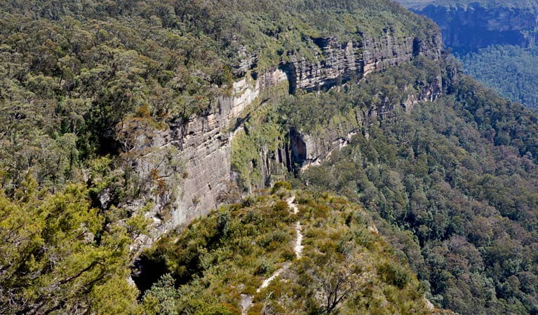
The Grand Canyon in the Blue Mountains is one of the most breathtaking and accessible natural wonders in New South Wales. This picturesque canyon is renowned for its dramatic sandstone cliffs, lush vegetation, and serene walking tracks. Starting from Evans Lookout, the Grand Canyon offers a memorable adventure through one of the region’s most scenic landscapes.
Getting There
Location: The Grand Canyon is located in the Blue Mountains National Park, near the town of Blackheath.
Access:
- By Car: From Sydney, take the M4 motorway towards the Blue Mountains. Exit onto the Great Western Highway (A32) and follow signs to Blackheath. From Blackheath, follow the signs to Evans Lookout.
- Parking: There is a car park at Evans Lookout. Note that parking can fill up quickly on weekends and holidays, so arrive early if possible.
Starting Point: Evans Lookout
Evans Lookout offers stunning panoramic views of the Grose Valley and the surrounding Blue Mountains. It’s an ideal starting point for your Grand Canyon adventure. Before beginning your hike, take some time to enjoy the lookout and capture some photos of the breathtaking views.
Starting Out: Begin your hike at Evans Lookout and follow the well-marked track leading down into the canyon. The descent is steep but manageable with well-maintained steps and pathways.
Entering the Canyon: As you descend, you’ll be surrounded by towering rock walls and lush greenery. The cool shade and serene atmosphere make this section of the walk particularly enjoyable.
Grose Valley Views: Along the way, take advantage of lookout points that offer stunning views back towards the Grose Valley.
Circular Route: The loop trail will lead you back up through a different path, gradually ascending out of the canyon. The return route provides different perspectives of the landscape and additional scenic points.
Dry Canyon – Newnes Plateau

Distance: Approximately 6 km round trip
Duration: 3-4 hours, depending on pace and time spent exploring the canyon
Difficulty: Moderate (The trail includes some scrambling and narrow sections within the canyon.)
Trail Type: Out-and-back (The hike begins and ends at the Glow Worm Tunnel Car Park, with the same route used for both inbound and outbound journeys.)
Dry Canyon, located in the Newnes Plateau of the Blue Mountains, NSW, is a remarkable natural feature offering a unique adventure for hikers and canyoners. This guide will provide detailed information on how to explore Dry Canyon, starting from Glow Worm Tunnel Road.
Getting There
Starting Point: Glow Worm Tunnel Road
- By Car: The journey to Dry Canyon starts from Glow Worm Tunnel Road, accessible from Lithgow. Drive along the Great Western Highway and turn onto State Mine Gully Road, which becomes Glow Worm Tunnel Road. Continue driving until you reach the car park for the Glow Worm Tunnel.
Trailhead: Glow Worm Tunnel Car Park
- Coordinates: -33.3862, 150.1934
- Facilities: Parking, basic toilets
Route Overview
- Initial Walk (2 km): Begin your hike from the car park, heading towards the Glow Worm Tunnel. The track is well-marked and follows the old railway line used for shale mining.
- The turnoff to Dry Canyon: After approximately 2 km, you’ll see a turnoff towards the Dry Canyon. This section is less marked, so keep an eye out for the trail indicators or use a GPS device.
- Entering Dry Canyon: The entrance to Dry Canyon is marked by a narrowing of the trail, leading into the slot canyon. Here, the adventure truly begins as you traverse through the canyon’s narrow passages and rock formations.
If you have time, explore the nearby Glow Worm Tunnel. It’s a short walk from the car park and offers a magical experience of seeing glow worms illuminate the tunnel’s walls.
Katoomba Round Walk Guide

Distance: Approximately 7 kilometers (round trip)
Duration: 2-3 hours
Difficulty: Moderate
Elevation Change: 300 meters
The Katoomba Round Walk is a popular and scenic trail in the Blue Mountains National Park, NSW. Starting from Scenic World, this walk offers stunning views of iconic landmarks like the Three Sisters, Katoomba Falls, and Jamison Valley.
Starting Point: Scenic World
Address: 1 Violet Street, Katoomba NSW 2780
Scenic World is the perfect starting point for the Katoomba Round Walk, offering ample parking, visitor facilities, and access to the Scenic Railway, Scenic Skyway, and Scenic Cableway.
1. Scenic Railway
Start your journey with a ride on the Scenic Railway, the steepest passenger railway in the world. This thrilling descent into the Jamison Valley sets the stage for an unforgettable walk.
2. Jamison Valley Rainforest
As you exit the Scenic Railway, you’ll find yourself in a lush rainforest. The boardwalk here offers an easy and accessible start to your hike, with interpretive signs explaining the flora and fauna.
3. Federal Pass
Follow the Federal Pass track, which winds through the valley floor. This section is relatively flat and shaded, making it a pleasant walk through the ancient forest.
4. Katoomba Falls
Continue along the track to Katoomba Falls, a stunning waterfall that plunges over the cliff into the Jamison Valley. There are several viewing points along the way, offering breathtaking views of the falls and the surrounding landscape.
5. Furber Steps
Ascend the Furber Steps, a challenging but rewarding climb back up to the cliff top. This section of the walk involves numerous stairs, but the views make it worthwhile. Take your time and enjoy the scenery.
6. Three Sisters
At the top, follow the Prince Henry Cliff Walk towards Echo Point, where you can see the iconic Three Sisters rock formation up close. This is one of the most photographed spots in the Blue Mountains.
7. Prince Henry Cliff Walk
Continue along the Prince Henry Cliff Walk, which offers panoramic views of the Jamison Valley and the Blue Mountains escarpments. This well-maintained track takes you back towards Scenic World.
8. Scenic Skyway (Optional)
For an additional thrill, take a ride on the Scenic Skyway. This cable car crosses the valley, providing stunning views from above, including a unique perspective of Katoomba Falls and the Three Sisters.
The Giant Stairway and Dardanelles Pass Loop

Total Distance: Approximately 5.4 kilometers
Duration: 3-4 hours
Difficulty: Moderate to Hard
The Giant Stairway and Dardanelles Pass Loop is a scenic and adventurous hike located in the Blue Mountains National Park, NSW. This loop trail takes you through lush rainforests, past majestic waterfalls, and offers breathtaking views of the iconic Three Sisters rock formation. The hike is challenging and suitable for experienced hikers.
Getting There
- By Car: Drive to Cliff Drive, Katoomba. There are parking areas available near Echo Point.
- By Public Transport: Take a train to Katoomba Station and then a bus or a short taxi ride to Echo Point.
- Starting Point: Cliff Drive
- Begin your hike from Cliff Drive, heading towards Echo Point.
- Enjoy the initial views of the Jamison Valley and the Three Sisters.
- Echo Point to Giant Stairway
- From Echo Point, follow the signs to the Giant Stairway.
- The descent is steep and requires caution. Take your time on the stairs and enjoy the close-up views of the Three Sisters.
- Base of the Giant Stairway
- Once at the valley floor, follow the Federal Pass track.
- The trail is well-marked and takes you through dense rainforest with occasional creek crossings.
- Leura Forest
- Continue along the Federal Pass until you reach Leura Forest.
- This is a great spot for a break, with picnic tables and beautiful surroundings.
- Dardanelles Pass
- Follow the signs to Dardanelles Pass, which loops back towards Katoomba.
- This section of the trail is less crowded and offers a peaceful hiking experience through the forest.
- Climb Back to the Escarpment
- The trail eventually starts to climb back up towards the escarpment.
- The ascent is gradual but can be challenging. Ensure you have enough water and take breaks as needed.
- Return to Cliff Drive
- The trail emerges back onto Cliff Drive, completing the loop.
- Enjoy the final views of the Blue Mountains before returning to your starting point.
Trail Highlights
- Three Sisters: The famous rock formation is a must-see, offering stunning views and photo opportunities.
- Giant Stairway: A steep descent with over 800 steps that takes you from the top of the escarpment to the valley floor.
- Dardanelles Pass: A serene trail through the forest that loops back towards the starting point.
- Scenic Lookouts: Numerous vantage points along the way provide panoramic views of the Blue Mountains.
Mount Solitary with Ruined Castle

Total Distance: Approximately 18 km return
Total Duration: 8-10 hours (full day hike)
Difficulty: Hard
Mount Solitary is a challenging yet rewarding hike offering stunning views of the Blue Mountains and the iconic Ruined Castle rock formation. Here is a route starting from The Golden Staircase, a steep descent into the valley, followed by a hike to Ruined Castle and then a climb to the summit of Mount Solitary.
Getting There
- By Car: Drive to the Golden Stairs car park located off Glenraphael Drive, Katoomba. It’s about a 10-minute drive from Katoomba town center.
- By Public Transport: Take a train to Katoomba Station, then catch a local bus or taxi to the car park.

The Route
- Starting Point: The Golden Staircase
- Begin your hike at The Golden Staircase, a steep and rocky descent that drops you quickly into the Jamison Valley. The staircase is well-maintained but requires caution, especially after rain.
- Key Points: Watch your step and use the handrails provided.
- Ruined Castle
- After descending The Golden Staircase, follow the Federal Pass walking track. This part of the track is relatively flat and shaded by lush forest.
- You’ll come across signs directing you to the Ruined Castle, a collection of large rock formations that resemble a castle. The ascent to Ruined Castle involves a short but steep climb.
- Key Points: Enjoy panoramic views of the surrounding valleys and Mount Solitary from the top of Ruined Castle. This is a good spot for a rest and a snack.
- Mount Solitary Ascent
- Continue along the Federal Pass track until you reach the track junction for Mount Solitary. The path up Mount Solitary is steep and rugged, requiring a good level of fitness and experience.
- The track is marked but can be challenging to follow in some areas. Expect some rock scrambling and be prepared for a strenuous climb.
- Key Points: The ascent offers incredible views back towards Katoomba and the Three Sisters.
- Summit of Mount Solitary
- The summit of Mount Solitary offers breathtaking 360-degree views of the Blue Mountains. On a clear day, you can see as far as the Sydney skyline.
- Take some time to explore the summit and enjoy the serene beauty of the area.
- Key Points: Be cautious near cliff edges and ensure you have enough time for the return journey.
- Return Journey
- Retrace your steps back down Mount Solitary, past Ruined Castle, and along the Federal Pass track.
- Ascend The Golden Staircase to return to your starting point.
- Key Points: The return journey is equally challenging, so pace yourself and take breaks as needed.
What to Bring
- Water: At least 3 liters per person.
- Food: High-energy snacks and a packed lunch.
- Clothing: Layered clothing suitable for changing weather conditions, sturdy hiking boots, and a hat.
- Navigation: A map of the area, a compass, and a GPS device or app.
- First Aid Kit: Basic supplies including bandages, antiseptic, and blister care.
- Sun Protection: Sunscreen and sunglasses.
- Torch: In case you return after dark.


